|
|
Severe winter forecast or not?
The coming winter will have many factors running i.e. Colder than normal SST and the fact that we are in a El Niño year Other Factors QBO, Polar Magnetic Shift -but this does not atomically mean we will have a severe winter it can also go the other way to wet and windy. The forecast Autumn September Will start off cool and wet but it will soon become dryer with sunny spells later as go towards mid-month it will come more unsettle with low pressure over France moving north so becoming unsettled with thundery rain moving north - towards the end of the month I expect a cold blast of northerly winds and the first snow over the Scottish mountains. Temps: average Rainfall: below average Weather Warnings: Hill Snow October Will start off cool with wintry showers over Scotland and the north of Ireland , dryer further south with high pressure moving up from France. By mid-month I expect to see a large high over the continent and this will influence our weather so turning dryer everywhere feeling warm in the sun. At the end of the month I expect a weather front to move south, following on very cold air and snow showers will start to affect the north of England and Scotland. Temps: average Rainfall: below average Weather Warnings :Hill Snow November Will start off cold and wintry still some snow showers over high ground it will gradually become more settled for a time as high than normal heights build from the east - I expecting a deep area of low pressure to develop and this will move in to the south west it will then become very stormy winds up 80 mph + and it will feel cold despite a southerly wind. Temps: average Rainfall: below average Weather Warnings: Severe Winds Winter December Will start off wet and cold with some wintry conditions over the high ground in the north, it will however become more settled as a large high extends from the continent around mid-month (14th 15th) the high will later move south allowing a trough to move south introducing much colder air also a deep low pressure system will spins off the Atlantic as this low hits the very much colder air moving south I expect to see blizzard conditions for a time around Christmas so if I'm right it will be a very white Christmas ! This type of wintry weather will continue through to the new year’s eve when another deep low will spread more snow. Temps: below normal Rainfall/Snowfall : above normal Weather warnings: Stormy Blizzards January As we start the month it will be very stormy with widespread snow showers and very icy conditions but as we move towards say mid-month I am expecting more settled conditions to develop with a large area of high pressure over the continent but this wiil give severe frosts at night - I am also forecasting a strong SSW and this will have a major factor over our weather with the large area of high pressure moving over Scandinavia and this introducing very cold Siberian air Temps: below normal Rainfall/Snowfall : normal Weather Warnings: turning much colder February Will start off very cold with easterly winds and snow flurries but in to the second week I am expecting a very deep area of low pressure to move in off the Atlantic as this hits the very cold air I am expecting a major blizzard to affect most of the UK and Ireland it will briefly turn less cold but the overall theme for the rest of the month will cold or very cold and snowy. Temps: below normal Rainfall /Snowfall : above normal Weather warnings: Stormy Blizzards I will be giving updates throughout the autumn and winter here at metjeffuk So keep coming back. But whatever your weather enjoy it! bye for now Jeff The Metjeffuk 2015/16 Autumn & Winter forecast dated 6-9-2015 |
|
|
WINTER UPDATE 2014/15 PLEASE SCROLL DOWN THE PAGE
NOTE FORUM AT BOTTOM OF PAGE. Thanks for coming to my web site you will be helping METJEFFUK if you click on the adverts Thank You. Right so here is my 2014/15 METJEFFUK.COM Winter Forecast today is the 1st of September 2014 Please remember this forecast is just for fun and it is what I think might happen METJEFFUK.COM will be not be responsible for any inaccuracy’s in the forecast. Please do not copy or reproduce forecasts without permission. ((((((UPDATED WINTER 2014/15 FORECAST)))))) Seasonal outlook - September 1st, 2014 Winter Ahead: STARTS STORMY AND WET ENDS VERY COLD WITH SNOW Issued: Monday1st September 2014 Forecaster: Jeff Jacobs October This month will start off rather cloudy with a lot of windy wet weather in the north and over Ireland, And it looks like this sort of weather will move further South in to Western and southern areas on the mild side in most parts at first. Second Half As we go in the end of October I think we will have the first taste of winter with a strong and very cold northerly wind coming strait down from the arctic this will give snow showers to most parts in the north and over high ground above 300mts in the south feeling cold with night frosts. November This month will start off very stormy with winds up 80 mph heavy rain and in the far north cold enough for snow -temps above normal in the south feeling cold in the north. Second Half As go in the second half I think a very strong jet stream will develop bringing rain and strong winds back across the whole country it will be mild or very mild- Towards the end of the month I expect high pressure to move up from France this will give southern areas some what drier conditions mild by day but frosty at night. but staying wet and windy and feeling rather cold with snow over the hills further north. December This month will be become very stormy again with winds up 85 mph heavy rain and in the north cold enough for snow even at lower levels with drifting in the winds in the north , it will be cold in the south but I think here precipitation will most likely be of rail or sleet rather than snow at this stage. Second Half As we go in to the second half of December low pressure will move into the France and the low countries with higher than normal heights over Scandinavia this will give us all an east to north east winds and with time these winds will become colder and colder with a lot of the precipitation starting to turn more and more wintry . Christmas Prediction [Dated 1st of September 2014] **so my all important prediction is for a white Christmas for most of us everywhere but more likely towards the north and east January After a cold end to December January will start less cold but i expect a very deep depression will move across northern Scotland following on behind very cold air from the arctic this will give widespread snow to all areas Second Half Snow showers almost anywhere but especially over high ground above 100mts giving blizzard conditions at times temperatures getting down to minus 15c in parts of Scotland as the jet will pushed further south in the med giving wild weather down there too. Snow Showers dieing out later as high pressure moves in from the Atlantic February With the high pressure moving off in to the continent I expect some very low day and especially night temperatures with freezing fog in central and eastern areas in Scotland ,England, and Ireland. Second Half The high will be replace with low pressure that will sink south from the arctic along with snow which could be heavy and prolonged giving 1-2mts in places [around 6ft] I expect February will be a another very cold wintry month but there will be one or two less cold interludes these around 18th 19th and 20th. March I think if I am right March 2015 will go down in the history books as being the coldest and snowiest March on record - Very cold air from Siberia combined with low pressure, with the jet stream well south I expect more snow fall, but it will be the cold that will affect most people in the biting north east wind. Second Half The cold theme continues with more snow fall especially in South West Britain with a very deep low pressure system moving up the English Channel giving Blizzards conditions here I 'm going for a date around the 21st of March this is defiantly one too watch! So there you have it the metjeffuk.com 14/15 winter forecast we will at the of the March see how accurate or not I have been of course I don't expect it to go week by week as forecast but the general theme of the forecast will one of a mild start and very cold end, we will see. Thanks again for reading check the video love to hear your comments on my blog page, and please don't forget too click on the adverts but as as always................. Whatever your weather enjoy it NOW GO TO THE FORUM BOTTOM OF PAGE Disclaimer Our long range weather forecasts are currently experimental and are produced using techniques that have not been validated. Our short and medium range weather forecasts (0 to 7days ahead) make use of data from various weather models such as the Global Forecast System (GFS).European Centre for Medium-Range Weather Forecasts (ECMWF) Metjeffuk.com accept no liability for any loss howsoever arising from use of this web site, or software, or services acquired from metjeffuk.com. And metjeffuk.com reserves the right to change, remove or add new sections to the site without notice. All features on the site including forecasts and data are provided on an ‘as is’ or ‘if available’ basis. Pages and/or applications provided by metjeffuk.com may not be available or may be displaying out of date information when you access them. |
|
Overview
A colder then average spring.
Temperature
The spring is expected to be colder than average with night frosts above normal over the 3 month period.
Precipitation
Close to or slightly below average over the 3 month period.
March
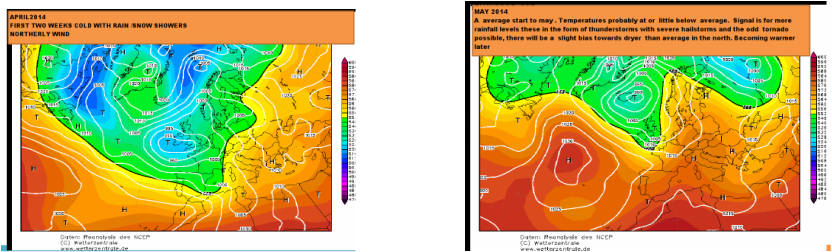
Starts off wet and windy but soon becoming dryer with high pressure near or over the country. Last two week will become more unsettlede and colder with rain and strong winds and as it gets colder snow will be in the forecast severe night frosts.
April
Temperature: Below average
Precipitation: Close to or below average
FIRST HALF
The first half of the month will start with unsettled weather and rather chilly conditions across the country. Snow will be in the forecast the first two weeks but Temperatures should recover later.
SECOND HALF
The second half of the month is expected to start off changeable in the north west, but drier further south and east. Temperatures at this stage possibly average in southern regions, and close to or slightly above average in the north. Later in the period dryer conditions probably extending further north . Temperatures becoming close to average.
MAY
Overview
A average start to may . Temperatures probably at or little below average. Signal is for more rainfall levels these in the form of thunderstorms with severe hailstorms and the odd tornado possible, there will be a slight bias towards dryer than average in the north.
FIRST HALF
Temperature: Below average at first quickly recovering CET normal or above normal.
Precipitation: Close to or above the average. The first half of the month will start with unsettled weather and rather chilly conditions across the country.an increasing threat of Thunderstorms and severe Hailstorms.
SECOND HALF
Temperatures should recover in the last two weeks to normal or above, Becoming increasingly warm in southern and central regions, but probably remaining close to average in the north and near coasts . For a time it may also become significantly drier and warmer in southern regions, but a more unsettled and windy picture is expected further north and west .
