metjeffuk.com
  • Autunm and winter forecast 24/25
  • FARMERS & GROWERS FREE 7 DAY FORECAST
  • HOME
  • HELPING METJEFFUK
  • LINKS PAGE
  • ARCHIVE OF LONG RANGE FORECASTS
  • December 2015 Statistics
    • r11
  • Forecast or Not!
  • All About Weather
    • MINI ICE AGE OR NOT?
  • ABOUT METJEFFUK / CONTACT
    • 2020/21 Autumn and Winter forecast
  • CONTACT
    • Spring and Summer Long rang Forecast 2021 >
      • 2017-18 Autumn and Winter Forecast
  • Metjeffuk video's
  • Martin Jennings Memorial Run Weather
    • Privacy Policy
  • Metjeffuk Spring /Summer fore cast
    • SOUTH WEST'S WEATHER FORECAST
    • storm page >
      • SPACE NEWS >
        • 21/22 Autumn Winter forecast
  • SSW
  • Spring Summer LRF 2022
  • Winter 23-24 forecast

STORM AGNES

 Welcome to the Southwest Weather Storm Page. here you will find the latest storm weather which may be affecting the SW of England and the latest forecast or predicted storms that may affect the region and updates on the lightning rain radar Snow Ice and severe winter weather

Picture

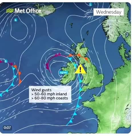
The first named storm of the autumn and winter season is expected to hit the United Kingdom and Ireland on Wednesday.

It has been named by the Met Office, Storm Agnes is likely to bring damage and disruption from strong winds and heavy rain. we are expecting wind gusts of 70 80 mph
UPDATES
With the Met Office severe weather warnings are already in force but you can expect to get further updates from the metoffice and of course Metjeffuk.com  as the week progresses.

Storm Agnes will move in from the south-west on Wednesday and up through the Irish Sea to affect northern areas of the UK.
How was it named?
The storm was named after a deep area of low pressure developed in the Atlantic which is enhanced by some energy from ex-Hurricane Ophelia which hit the north-east coast of the United States over the weekend and has it hits the powerful Jetstream will help to deepen it rapidly.
Picture
​

CONFIDANCE
There are still some uncertainties in the details of the forecast the most likely scenario is for a swathe of strong winds with gusts of 60-70mph  to affect inland areas. Some Irish Sea coastal parts though could see gusts of 65-75mph  with a chance of 80mph  in some exposed areas.

These wind speeds have the potential to bring travel disruption with bridges closed or ferry services cancelled. Trees may come down and power supplies may be cut in some areas. There is also the potential for injury and damage to property. In addition to strong winds, there'll also be some heavy rain which follows what has already been a very wet period and the in the SW high tides in the late afternoon of Wednesday may give an real treat of coastal flooding.
The 2023-24 storm season started on 1 September which also means there is a new set of names established in collaboration between the UK Met Office, Ireland's Met Éireann and the Royal Netherlands Meteorological Institute.

What's Next?
After  Agnes  we look at the storm following on for Thursday again with 70 to 80 mph gusts possible  more updates soon


Powered by Create your own unique website with customizable templates.